
Franciscan Cadastre Maps for Genealogy
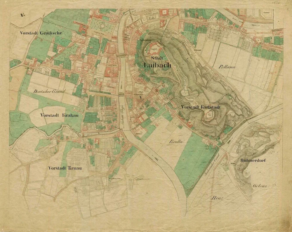
Laibach - Ljubljana 1826 Cadastral Map
What are the Cadastral Maps and How Are They Useful for Genealogy?
The Habsburg Franciscan Land Cadastre
Franziszeische Kataster, Francijscejski Kataster,
Catasto Franceschino
The Habsburg Cadastral Land Register, or Franciscan Cadastre, encompassed the Austrian Lands of the Habsburg Monarchy. On December 23rd 1817, Emperor Franz Joseph 1st ordered the creation of the Cadastre for the purpose of creating a land tax (Grundsteuer) register, based on land and building ownership. The results of the Cadastre were used to calculate individual tax payable.
Every cadastral municipality was surveyed between 1817 and 1861. Drawn by hand, it was a massive undertaking for its time!
Between 1817 and 1866, 30 Million Hectares were measured, including 49 Million land plots in 30,556 Cadastral Municipalities (Source franziszeischerkataster.at)
Cadastre / Cadaster - Inventory of Land Use and Owners
Cadastral Map - Borders of Land Ownership & Use
The Franciscan Cadastre covered the territory of Austria, Slovenia and parts of Italy - in today’s Friuli Venezia Giulia (plus Croatia, Hungary, Bosnia and Herzegovina, Slovakia, Czechia and parts of Serbia, Ukraine, Romania, Poland and Montenegro).
The Franciscan Cadastre includes the wonderful maps we now treasure for our genealogy, a register of land and building plots, an alphabetical list of land owners, valuations of the cadastral communities, land usage.
Katastermappe - Katastrska Mapa - Mappe Catastale
What’s found on the cadastral maps?
Many useful things such as:
Land borders
Plots - Parzellen
Plot numbers
Buildings
Creeks and rivers
Churches and cemeteries
Water mills
Paper mills
Fields
Roads and paths
Types of agriculture
Monuments
Cadastral maps and genealogy
The numbers recorded on the Cadastral map represent land and building plot numbers, not the actual house/home/street numbers.
The Parzellenprotokol, recorded house number, land usage, size of land, name of owner etc - and the plot number.
Tips:
* Take extra care with the German numbers 1 and 7 as they’re easily confused.
* Be certain of the house number before looking in the register (Parzellenprotocol). You can often find your ancestors house number in their baptism, marriage or death record on Matricula.
What if your ancestor wasn’t recorded in the cadastre?
It may be that your ancestor did not own land or property but rented it. In that case you won’t find them in the Cadastre registers (Parzellenprotokol) but you will find the actual owner of the land - still useful for your family history. You’ll often see that one person owned numerous plots.
Perhaps your ancestors were not in that area - yet. That may be a really useful indicator if you know they moved into a new town at some point but don’t know when.
Cadastre map legend
To get the most out of the Cadastral Maps, you’ll need an original Zeichen Muster (Map Legend) which can be downloaded and at Arcanum. The map legend is really fascinating! It shows what you see on the map such as the type of agriculture, types of forest, mills, churches etc.
Franciscan Cadastre sources :
Arcanum Search a town, remove either the Cadastral Map or current Google Map or view them both in a split screen.
VAČ (Virtual Reading Room) Archives of the Republic of Slovenia.
KAGIS Kärnten Kärnten Kataster/Cadastral map
GIS Steiermark Steiermark Kataster/Cadastral map
Kärntner Landesarchiv, Steiermark Landesarchiv
Archivio di Stato di Trieste Cataster online including Prebačina, Monfalcone, Pontebba/Pontafel, Gorizia/Görz and many Slovenian villages.
Archivio di Stato di Pordenone
Archivio di Stato di Gorizia
Each Cadastral Municipality is identified by a number (still used today):
Kastralgemeinde KG Nummern Kärnten and Steiermark
Katastrska Občina KO
This article has excellent detail of what can be found on the maps: The Franziscean Land Cadastre as a Key to Understanding the 19th Century Cultural Landscape in Slovenia