Route Editor

| Guide | ♦ | 11 Triplogs | 1 Topic |
details | drive | no permit | forecast | route |
stats |
photos | triplogs | topic | location |
| 140 | 11 | 1 |
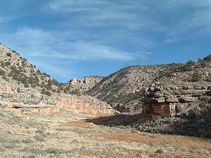
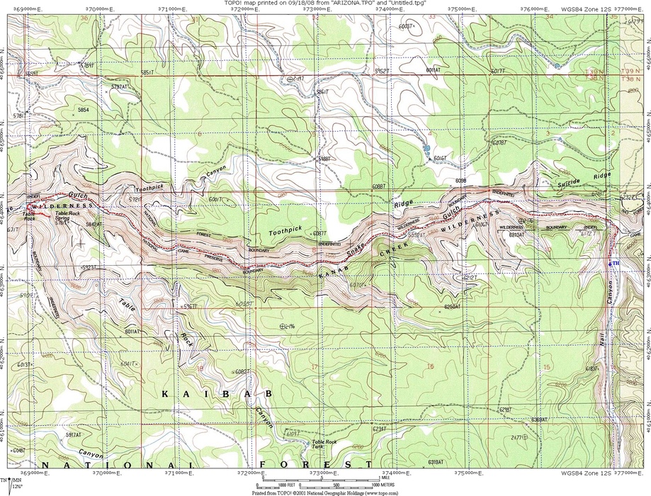
Gateway to Kanab Creek by PaleoRob  Snake Gulch is a beautiful canyon located on the Kaibab National Forest, North Kaibab Ranger District. While providing access into the famed Kanab Creek Wilderness (indeed it lays within the wilderness) and Kanab Creek, the hike from Snake Gulch to Table Rock is worthwhile in its own right, and easy backpacking trip or a day hike. Where the Forest Road ends is where the trail begins. There is a shade ramada with a little information about Snake Gulch, the wilderness, but not reams. There's a trail register as well as a picnic table. Park out of the cul-du-sac area, to not block any other vehicles that may be trying to turn around.
Within the next mile or so, the arroyo disappears, and the canyon bottom levels out. The trail makes some branches, but is easy to follow, as the canyon has no real side canyons until reaching Table Rock. The tumbleweed can sometimes be troubling and itchy. I recommend long pants or gaiters. Keep a sharp eye out for rock art and ruins! They can be found the entire length of the canyon, from the corral down past Table Rock. The rock art is spectacular in Snake Gulch, probably one of the best collections of pictographs in the state. Most of it is very old too, Anasazi Basketmaker and Fremont from the same period. Some newer images, from Pueblo III times, and even the occasional Paiute drawing, but the bulk (and the draw) are the very large, ancient pictographs. Red was a favorite color for the ancient inhabitants of Snake Gulch, so keep your eyes peeled for splashes of red against the tan walls. These can indicate the presence of just a few little PIII humanoids, or a battery of ancient, towering figures. Keep an eye out for "The Spacemen" and "The Couple" on your way down. Ruins are also found in Snake Gulch, and the sharp eye can usually spot the remains of some cliff dwellings as you get closer to Table Rock. The trail stays simply in the bottom of the canyon. Table Rock marks the confluence of Snake Gulch and a medium-sized tributary coming in from the south. At their junction, a point sticks out with a flat limestone bench at the top - Table Rock. An extensive pictograph panel, The Big Panel, is sheltered under the overhang of Table Rock. There is also an ammo can with a visitor's log. Across the canyon is an alcove with a cliff dwelling (just a few walls, now). A trip up into the ruin is neat, though the main attraction is the rock art. The Big Panel alone is worth spending hours, if you have them, alone on. Journeys up the side canyon and down Snake Gulch further are rewarding. The view, especially at sunset, from the next few bends in Snake Gulch, is terrific as the canyon deepens. If you are camping at Table Rock (and it makes a great base camp for exploring), please don't camp in front of the Big Panel or the cliff dwelling. Under the point of Table Rock has been used often, so practice low impact camping and try to concentrate there. Just up the side canyon is an old cattle tank that's usually full - its piped from a spring up the side canyon and provides an excellent water source. Or you can go directly to the spring, but most of its flow goes down to the tank. Don't forget to treat the water - errant cows occasionally cross into the wilderness through breaks in the fences. Table Rock is an excellent destination for the day, as a basecamp, or as a stopover on a longer journey into the Kanab Creek Wilderness. It's isolated and hardly visited, so despite the good roads to the trailhead. I have never seen another party in the canyon. The rock art is world-class, and the hiking is easy. What's not to like? Check out the Official Route and Triplogs. Leave No Trace and +Add a Triplog after your hike to support this local community.
| |||||||||||||||||||||||||||||||||||||||||||||||||||||||||||||||||||||||||||||||||||||||||||||||||||||